• Please visit and share your knowledge at our sister communities:
  • If you have not, please join our official Homebrewing Facebook Group!

    Homebrewing Facebook Group

Name That Skyline - Picture Game

Homebrew Talk

Help Support Homebrew Talk:

This site may earn a commission from merchant affiliate links, including eBay, Amazon, and others.
This airport one is throwing me...

The mountains look like high desert, and Photopilot is from SoCal, so there's a part of me thinking it should be somewhat local. But all the grass at and around the airport looks WAY too green. Meaning "someplace that gets natural rain" green. That's not anywhere local that I can think of...

But I'm going to do some searching... I can think of places along the coast which might have enough precipitation and be near mountains like this that could possibly work.

I lived in the high desert for a while (Hesperia), and those mountains don't look the same to me.
 
Hailey, ID (Friedman Memorial Airport)?

KSUN

I got to figure Matt you are not originally from New Orleans, you have been to too many places. This is Hailey in early spring. No snow but still green. Hailey is pretty lush but the area starting 15 miles south is all high desert. I am mostly out of city images you might be seeing more aerial images from me in the future.
 
KSUN


I got to figure Matt you are not originally from New Orleans, you have been to too many places. This is Hailey in early spring. No snow but still green. Hailey is pretty lush but the area starting 15 miles south is all high desert. I am mostly out of city images you might be seeing more aerial images from me in the future.


Good stuff as a fellow pilot and air traffic controller I look forward to more. I've got one waiting for my turn too.
 
KSUN

I got to figure Matt you are not originally from New Orleans, you have been to too many places. This is Hailey in early spring. No snow but still green. Hailey is pretty lush but the area starting 15 miles south is all high desert. I am mostly out of city images you might be seeing more aerial images from me in the future.

Nice job! That's definitely a tough one!
 
KSUN

I got to figure Matt you are not originally from New Orleans, you have been to too many places. This is Hailey in early spring. No snow but still green. Hailey is pretty lush but the area starting 15 miles south is all high desert. I am mostly out of city images you might be seeing more aerial images from me in the future.

No, I'm born and raised in New Orleans, though I did live in SoCal for a bit in 2002 when I graduated high school, and again in 2005 (post-Katrina). I do like to travel though, but probably not as much as bwarbiany!

That one was tricky, but I actually found it somewhat quicker than I thought I would thanks to google-fu. I, like bwarbiany, scoped out a lot of SoCal places that I thought might ring true, but found nothing. I noticed the strip appeared to run north-south, and the image appeared to be looking north (thanks, shadows!). So then I just straight up searched "airstrip near mountains" and went through dozen of photos before I found one of KSUN but from the north looking south. It looked like it could be but I couldn't tell from the reverse angle, so to Maps I went and everything seemed in order.

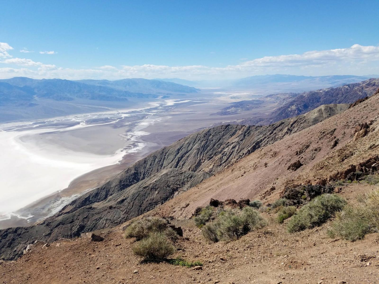
Here's one that should be pretty easy I'd imagine. It's a slightly weird angle to somewhat mask the obviousness. Bonus points if you can name the spot this was taken from (it's known for being able to see 2 contrasting things at the same time - and though they technically both exist in this image, you really can only see one). Double bonus points if you can name both of those things and/or their significance.

Spoiler Alert: even though this is my image, Google seems to know what's up, so don't go searching Google for this image unless you're giving up!

13308629_10100467139551084_7736994660589095312_o.jpg
 
Owens dry lake bed. Off the 395, North of Mojave.

Yeah... what he said ^^^ :eek:

I've got to say, I thought I had traveled well enough to know some stuff but every time you guys post something such as "this is an easy one...yadda yadda yadda" I feel like one of those people that has never left their home state.
 
Yeah... what he said ^^^ :eek:

I've got to say, I thought I had traveled well enough to know some stuff but every time you guys post something such as "this is an easy one...yadda yadda yadda" I feel like one of those people that has never left their home state.

Ha I hear you, I guess it seems obvious to me since I was there. I only say that it was probably easy because of how popular and notable of a spot this is - it's not like it's some obscure dry lake bed (haha, j/k...well not really....:mug:).

But no, not Owens (Dry) Lake. In the right neighborhood though!
 
No, I'm born and raised in New Orleans, though I did live in SoCal for a bit in 2002 when I graduated high school, and again in 2005 (post-Katrina). I do like to travel though, but probably not as much as bwarbiany!

That one was tricky, but I actually found it somewhat quicker than I thought I would thanks to google-fu. I, like bwarbiany, scoped out a lot of SoCal places that I thought might ring true, but found nothing. I noticed the strip appeared to run north-south, and the image appeared to be looking north (thanks, shadows!). So then I just straight up searched "airstrip near mountains" and went through dozen of photos before I found one of KSUN but from the north looking south. It looked like it could be but I couldn't tell from the reverse angle, so to Maps I went and everything seemed in order.

Here's one that should be pretty easy I'd imagine. It's a slightly weird angle to somewhat mask the obviousness. Bonus points if you can name the spot this was taken from (it's known for being able to see 2 contrasting things at the same time - and though they technically both exist in this image, you really can only see one). Double bonus points if you can name both of those things and/or their significance.

Spoiler Alert: even though this is my image, Google seems to know what's up, so don't go searching Google for this image unless you're giving up!

That looks like the fualt lines near Death Valley, CA to me. but I can't answer the bonus questions
 
Also going with Death Valley. I'm figuring the 2 contrasting / significant things are Badwater Basin (lowest point in N. America) and Mt Whitney (highest point in the lower 48).
 
That looks like the fualt lines near Death Valley, CA to me. but I can't answer the bonus questions

Ding ding! Technically you were the first to name the place - DVNP, so that means you're up.

Also going with Death Valley. I'm figuring the 2 contrasting / significant things are Badwater Basin (lowest point in N. America) and Mt Whitney (highest point in the lower 48).

Well TheMadKing beat you to the answer, but you definitely get the bonus points! The pic is from Dante's View, and yes you can see both the highest and lowest points in the contiguous US from this one vantage point!

Just think - all of the land in the US, and these two points are only separated by <100 miles. Pretty crazy.
 
I know this will probably sound funny if I'm wrong, but....New York?

I've never been and I'm sure there's a bunch of obscurish skylines that aren't immediately recognizable. The fact that you don't want us snooping makes me think it's something really obvious. But I'm probably wrong?
 
Not New York but I would've guessed something similar if I hadn't been

Also, there's a building in the middle that's a very big hint (but it's not super well known)
 
I know this will probably sound funny if I'm wrong, but....New York?

I've never been and I'm sure there's a bunch of obscurish skylines that aren't immediately recognizable. The fact that you don't want us snooping makes me think it's something really obvious. But I'm probably wrong?

I cheated. I've been to this place, but certainly didn't recognize it. So, it wasn't obvious to me.
 
Since it may be tough I'll give two hints.

One: it's overseas.
Two: it's from the most famous place to get a view of the city (up until a few years ago when they built a really tall new building in the city) and you take a really scary escalator to get there

So... Let's guessing! (Also a clue if you've spent time there)
 
OK, I Googled "red and white antenna" and came up with one that looks like the right thing in Shiba Park in Tokyo, but I couldn't verify it by identifying any surrounding buildings on Google maps.
 
You're in the right area of the world (not the right country though)
 
I'm getting close to work so I'll give a big clue. It's the busiest train station in the world outside the city with the busiest train stations

Also look at the building in the middle, there's a highway that goes though the building (the city wanted to build a highway, the land owner wanted a building and neither gave in and both started building. It resulted in that)
 

Latest posts

Back
Top