You are using an out of date browser. It may not display this or other websites correctly.
You should upgrade or use an alternative browser.
You should upgrade or use an alternative browser.
Name That Skyline - Picture Game
- Thread starter arnobg
- Start date

Help Support Homebrew Talk:
This site may earn a commission from merchant affiliate
links, including eBay, Amazon, and others.
That looks like Tampa or St. Petersburg, FL my old neck of the woods.
Red...no, white hot, buddy!
Edit: In fact, pick one!!
That looks like Tampa or St. Petersburg, FL my old neck of the woods.
I guess there's no rule against making two guesses in one post. It is Tampa, probably taken from the Tampa General Hospital grounds on Davis Island. I lived there for 8 years back in the 80's.
I'm going to hand it to you, arnobg. Gotta go to bed!
arnobg
Well-Known Member
Okay ladies and gentleman this skyline photo shows more square miles than any other one posted yet. I took this from the air a few weeks ago. Should be pretty easy.
View attachment ImageUploadedByHome Brew1469358021.898847.jpg
View attachment ImageUploadedByHome Brew1469358021.898847.jpg
GrogNerd
mean old man
atlanta, ga
All I know is... I have to get out more.

$33.99 ($17.00 / Count)
$41.99 ($21.00 / Count)
2 Pack 1 Gallon Large Fermentation Jars with 3 Airlocks and 2 SCREW Lids(100% Airtight Heavy Duty Lid w Silicone) - Wide Mouth Glass Jars w Scale Mark - Pickle Jars for Sauerkraut, Sourdough Starter
Qianfenie Direct

$53.24
1pc Hose Barb/MFL 1.5" Tri Clamp to Ball Lock Post Liquid Gas Homebrew Kegging Fermentation Parts Brewer Hardware SUS304(Liquid Hose Barb)
Guangshui Weilu You Trading Co., Ltd

$58.16
HUIZHUGS Brewing Equipment Keg Ball Lock Faucet 30cm Reinforced Silicone Hose Secondary Fermentation Homebrew Kegging Brewing Equipment
xiangshuizhenzhanglingfengshop

$10.99 ($31.16 / Ounce)
Hornindal Kveik Yeast for Homebrewing - Mead, Cider, Wine, Beer - 10g Packet - Saccharomyces Cerevisiae - Sold by Shadowhive.com
Shadowhive

$176.97
1pc Commercial Keg Manifold 2" Tri Clamp,Ball Lock Tapping Head,Pressure Gauge/Adjustable PRV for Kegging,Fermentation Control
hanhanbaihuoxiaoshoudian

$479.00
$559.00
EdgeStar KC1000SS Craft Brew Kegerator for 1/6 Barrel and Cornelius Kegs
Amazon.com

$22.00 ($623.23 / Ounce)
AMZLMPKNTW Ball Lock Sample Faucet 30cm Reinforced Silicone Hose Secondary Fermentation Homebrew Kegging joyful
无为中南商贸有限公司

$53.24
1pc Hose Barb/MFL 1.5" Tri Clamp to Ball Lock Post Liquid Gas Homebrew Kegging Fermentation Parts Brewer Hardware SUS304(Liquid MFL)
yunchengshiyanhuqucuichendianzishangwuyouxiangongsi

$7.79 ($7.79 / Count)
Craft A Brew - LalBrew Voss™ - Kveik Ale Yeast - For Craft Lagers - Ingredients for Home Brewing - Beer Making Supplies - (1 Pack)
Craft a Brew

$20.94
$29.99
The Brew Your Own Big Book of Clone Recipes: Featuring 300 Homebrew Recipes from Your Favorite Breweries
Amazon.com
arnobg
Well-Known Member
atlanta, ga
Yup you got it sir. Had a good view of the new Mercedez Benz Stadium.
You're up
GrogNerd
mean old man
recognized the GA Dome, the Omni, where 75/85 splits and, if you wait another minute or 2, you'll see Mo's Pizza
next one up isn't a skyline, but it is a defining landmark. I don't have a picture of it, but a bing map screen cap should do. with the location identification scratched out, of course
the only clue you'll get: this location has been used before in this thread
good luck

next one up isn't a skyline, but it is a defining landmark. I don't have a picture of it, but a bing map screen cap should do. with the location identification scratched out, of course
the only clue you'll get: this location has been used before in this thread
good luck
Photopilot
Well-Known Member
Mobile AL.
Photopilot
Well-Known Member
That might also be the Recruit in San Diego. The white color and lack of landscaping makes it hard to be sure. If that is it I will be about 1/2 mile from it later today.
GrogNerd
mean old man
USS Recruit (TFFG-1), Point Loma, San Diego, CA
Landscaping and construction around the area is finished, that pic is a little dated
Plus, there's a brewery across the street. Which wasn't there when I went to boot camp in 1987
Landscaping and construction around the area is finished, that pic is a little dated
Plus, there's a brewery across the street. Which wasn't there when I went to boot camp in 1987
That might also be the Recruit in San Diego. The white color and lack of landscaping makes it hard to be sure. If that is it I will be about 1/2 mile from it later today.
I also came up with USS Recruit by Googling navy/ship/dry land (I don't have the search skills some of you guys have), but the pictures I got showed sidewalks around it, and not the sparse, desert-like surroundings.
EDIT: HAHA! I also type too slowly!
GrogNerd
mean old man
San Diego is a desert
San Diego is a desert
This is true. I actually lived in Escondido for a short while back in the early 70's. Yes, I'm old!
San Diego is a desert
When it comes to breweries and beer, it's an oasis.

Amen. I was at Ballast Point, Kilowatt, Société and Rough Draft yesterday, and having lunch at Stone today...
Kilowatt sucks BTW.
Kilowatt sucks BTW.
GrogNerd
mean old man
That might also be the Recruit in San Diego. The white color and lack of landscaping makes it hard to be sure. If that is it I will be about 1/2 mile from it later today.
USS Recruit (TFFG-1), Point Loma, San Diego, CA
Landscaping and construction around the area is finished, that pic is a little dated
Plus, there's a brewery across the street. Which wasn't there when I went to boot camp in 1987
If it wasn't clear, Photopilot, you were correct
so you're up
Photopilot
Well-Known Member
USS Recruit (TFFG-1), Point Loma, San Diego, CA
Landscaping and construction around the area is finished, that pic is a little dated
Plus, there's a brewery across the street. Which wasn't there when I went to boot camp in 1987
Here is the crazy part of this story. Last week I was supposed to say on my boat and bike to Dead Cover band at Liberty Station. I was trying to convince my wife it was viable plan and pulled up Google Earth to show her the route. So I was looking at this same image a week ago. It looks a lot different today.
Photopilot
Well-Known Member
I tried to post this morning from my other computer where I had to go to get some of my other photos but was rejected by the system. I then tried to punt it to someone else from my phone on the way down to my boat.
Here is the USS Recruit as I passed by it today. You can only see the antennas or crows nest.
I am trying to post something again but getting an error on my other computer.

Here is the USS Recruit as I passed by it today. You can only see the antennas or crows nest.
I am trying to post something again but getting an error on my other computer.

Photopilot
Well-Known Member
GrogNerd
mean old man
I tried to post this morning from my other computer where I had to go to get some of my other photos but was rejected by the system. I then tried to punt it to someone else from my phone on the way down to my boat.
Here is the USS Recruit as I passed by it today. You can only see the antennas or crows nest.
I am trying to post something again but getting an error on my other computer.

so, just to the left in this picture, that jut of land between Harbor Island and Shelter Island... that was my home for most of my Navy career in San Diego. it's the Fleet Anti-Submarine Warfare Training Center Pacific. or FLEASWTRACENPAC. you know the Navy loves it some abbreviations
man, I miss Adalberto's carne asada burritos
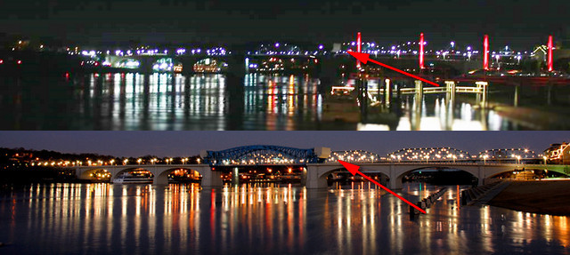
Wow, I was sure I could clearly see the arches of a bridge back there. Are you sure that's not Market St Bridge? Here's a couple of pics of it below. BTW, I know you live there, and you should know, but I'm just really surprised that the bridge in these pics below aren't the same as the bridge in your picture.
Also, I found it pretty quickly by just looking at your profile info and searching arched bridges in chattanooga. This one popped up. I thought it was a match.
View attachment 363136
No, the angle is off.
I'm going to say Big Bear City Airport
No, the angle is off.The pic I posted was parallel to the bridge

Sorry, I can't let it go. Am I the only one who sees a bridge in the image at the top? Top half is the original picture, bottom half is the bridge I think I see there. You can even see the counterweight of the drawbridge in the top there.

Sorry, I can't let it go. Am I the only one who sees a bridge in the image at the top? Top half is the original picture, bottom half is the bridge I think I see there. You can even see the counterweight of the drawbridge in the top there.
I suppose it's possible, but I was shooting parallel to the bridge, way down-river.
I suppose it's possible, but I was shooting parallel to the bridge, way down-river.
I'll have to go out during daylight and take a similar picture.
arnobg
Well-Known Member
I'm going to say Big Bear City Airport
I think you mean Big Bear Lake, but this isn't it.
I think you mean Big Bear Lake, but this isn't it.
Is it even in the USA? Just checking. I found one that might fit, but it wasn't in the USA
What about San Bernardino International Airport?
This airport one is throwing me...
The mountains look like high desert, and Photopilot is from SoCal, so there's a part of me thinking it should be somewhat local. But all the grass at and around the airport looks WAY too green. Meaning "someplace that gets natural rain" green. That's not anywhere local that I can think of...
But I'm going to do some searching... I can think of places along the coast which might have enough precipitation and be near mountains like this that could possibly work.
Similar threads
- Replies
- 45
- Views
- 4K
- Replies
- 163
- Views
- 14K
- Replies
- 252
- Views
- 22K
- Replies
- 337
- Views
- 29K
- Replies
- 157
- Views
- 18K


![Craft A Brew - Safale BE-256 Yeast - Fermentis - Belgian Ale Dry Yeast - For Belgian & Strong Ales - Ingredients for Home Brewing - Beer Making Supplies - [3 Pack]](https://m.media-amazon.com/images/I/51bcKEwQmWL._SL500_.jpg)


