Alazani?
You are using an out of date browser. It may not display this or other websites correctly.
You should upgrade or use an alternative browser.
You should upgrade or use an alternative browser.
Name That Skyline - Picture Game
- Thread starter arnobg
- Start date

Help Support Homebrew Talk:
This site may earn a commission from merchant affiliate
links, including eBay, Amazon, and others.
The Volga or the Ural, probably the Ural.
Terek River
Northern_Brewer
British - apparently some US company stole my name
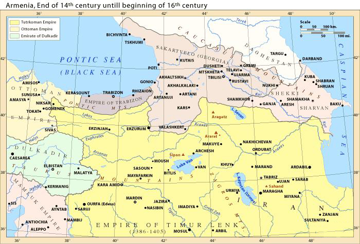
It is indeed the Terek, flowing east from Georgia, through Chechnya and Dagestan into the Caspian. It has featured in history several times. It marked the furthest point of the German advance towards the Baku oilfields in 1942, in 1262 it saw the Ilkhanate (southwest part of the Mongol Empire covering Iran/Iraq/Turkey) defeated by the Golden Horde (northwest part of the Mongol Empire extending from the Danube to Siberia), and on 14 April 1395 it saw Tamerlane (Timur) rout the Golden Horde leading to its eventual collapse.
The Terek is at the top of this map, the Timurid empire is in yellow.

The Terek is at the top of this map, the Timurid empire is in yellow.

Last edited:
A change of pace-


Notre Dame

$719.00
$799.00
EdgeStar KC2000TWIN Full Size Dual Tap Kegerator & Draft Beer Dispenser - Black
Amazon.com

$58.16
HUIZHUGS Brewing Equipment Keg Ball Lock Faucet 30cm Reinforced Silicone Hose Secondary Fermentation Homebrew Kegging Brewing Equipment
xiangshuizhenzhanglingfengshop

$44.99
$49.95
Craft A Brew - Mead Making Kit – Reusable Make Your Own Mead Kit – Yields 1 Gallon of Mead
Craft a Brew

$7.79 ($7.79 / Count)
Craft A Brew - LalBrew Voss™ - Kveik Ale Yeast - For Craft Lagers - Ingredients for Home Brewing - Beer Making Supplies - (1 Pack)
Craft a Brew

$10.99 ($31.16 / Ounce)
Hornindal Kveik Yeast for Homebrewing - Mead, Cider, Wine, Beer - 10g Packet - Saccharomyces Cerevisiae - Sold by Shadowhive.com
Shadowhive

$176.97
1pc Commercial Keg Manifold 2" Tri Clamp,Ball Lock Tapping Head,Pressure Gauge/Adjustable PRV for Kegging,Fermentation Control
hanhanbaihuoxiaoshoudian

$33.99 ($17.00 / Count)
$41.99 ($21.00 / Count)
2 Pack 1 Gallon Large Fermentation Jars with 3 Airlocks and 2 SCREW Lids(100% Airtight Heavy Duty Lid w Silicone) - Wide Mouth Glass Jars w Scale Mark - Pickle Jars for Sauerkraut, Sourdough Starter
Qianfenie Direct

$53.24
1pc Hose Barb/MFL 1.5" Tri Clamp to Ball Lock Post Liquid Gas Homebrew Kegging Fermentation Parts Brewer Hardware SUS304(Liquid Hose Barb)
yunchengshiyanhuqucuichendianzishangwuyouxiangongsi

$20.94
$29.99
The Brew Your Own Big Book of Clone Recipes: Featuring 300 Homebrew Recipes from Your Favorite Breweries
Amazon.com

$53.24
1pc Hose Barb/MFL 1.5" Tri Clamp to Ball Lock Post Liquid Gas Homebrew Kegging Fermentation Parts Brewer Hardware SUS304(Liquid Hose Barb)
Guangshui Weilu You Trading Co., Ltd

$22.00 ($623.23 / Ounce)
AMZLMPKNTW Ball Lock Sample Faucet 30cm Reinforced Silicone Hose Secondary Fermentation Homebrew Kegging joyful
无为中南商贸有限公司
![Craft A Brew - Safale S-04 Dry Yeast - Fermentis - English Ale Dry Yeast - For English and American Ales and Hard Apple Ciders - Ingredients for Home Brewing - Beer Making Supplies - [1 Pack]](https://m.media-amazon.com/images/I/41fVGNh6JfL._SL500_.jpg)
$6.95 ($17.38 / Ounce)
$7.47 ($18.68 / Ounce)
Craft A Brew - Safale S-04 Dry Yeast - Fermentis - English Ale Dry Yeast - For English and American Ales and Hard Apple Ciders - Ingredients for Home Brewing - Beer Making Supplies - [1 Pack]
Hobby Homebrew
No.
France
Not anywhere in France. It is continental Europe
Cologne cathedral
Santa Maria, Requena, Spain?
No, nor is it Germany
Beermanpete has it!Santa Maria, Requena, Spain?
You’re up
Here is your new skyline-ish image to ponder.


USA?
Yes.
Northern_Brewer
British - apparently some US company stole my name
University?
No.
CKuhns
Everything learned in Kindergarten still applies!
I believe its a Church in Joliet, Illinois. (Unfortunately dont remember the name.) I visited Joliet a number of times for work and remember thinking I would like to see inside it some day. Unfortunately never got the chance.
USA?
Looks like a California mission, but I don't know which one.
Is it the Alamo?
New Mexico
CKuhns
Everything learned in Kindergarten still applies!
I knew this was somewhat of an obscure location. Tonight, as i crawl into my man-made cave for some rest and reflection i will find a couple of additional pictures and post them in the morning to see if that sparks any additonal ideas of what and or where this may be.
Similar threads
- Replies
- 45
- Views
- 4K
- Replies
- 163
- Views
- 14K
- Replies
- 252
- Views
- 22K
- Replies
- 337
- Views
- 29K
- Replies
- 157
- Views
- 18K


