Deception Island, Antarctica?
You are using an out of date browser. It may not display this or other websites correctly.
You should upgrade or use an alternative browser.
You should upgrade or use an alternative browser.
Name That Skyline - Picture Game
- Thread starter arnobg
- Start date

Help Support Homebrew Talk:
This site may earn a commission from merchant affiliate
links, including eBay, Amazon, and others.
Northern_Brewer
British - apparently some US company stole my name
Bruce is very cold.
Pkrd is warm-ish I guess. Certainly has the right idea, but this one is not known as a harbour despite the "pond" in the middle.
Pkrd is warm-ish I guess. Certainly has the right idea, but this one is not known as a harbour despite the "pond" in the middle.
Heard Island?
Northern_Brewer
British - apparently some US company stole my name
I can see why you went there, but Pkrd was a lot warmer.
InspectorJon
Well-Known Member
Do I see some steam? Looks volcanic.
My. Terror or Drake Passage


$7.79 ($7.79 / Count)
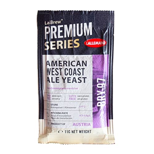
Craft A Brew - LalBrew Voss™ - Kveik Ale Yeast - For Craft Lagers - Ingredients for Home Brewing - Beer Making Supplies - (1 Pack)
Craft a Brew


$479.00
$559.00
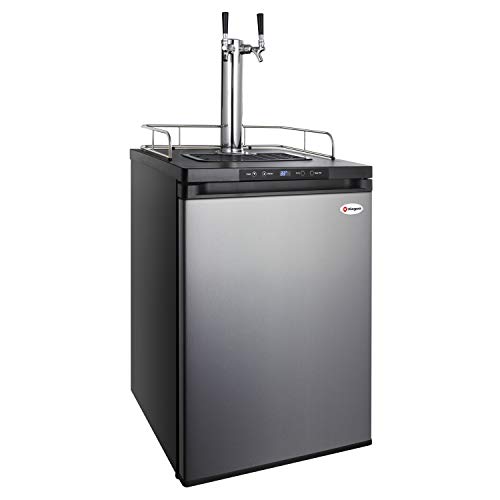
EdgeStar KC1000SS Craft Brew Kegerator for 1/6 Barrel and Cornelius Kegs
Amazon.com


$53.24
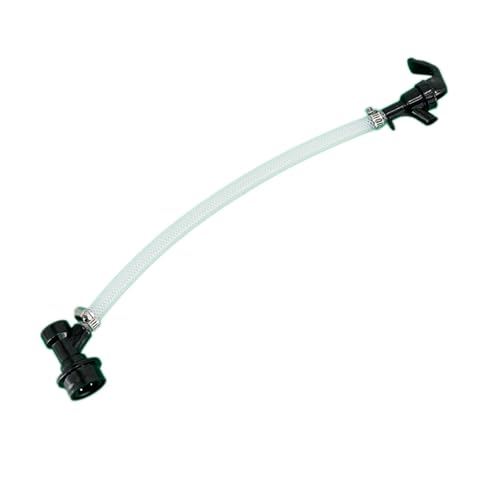
1pc Hose Barb/MFL 1.5" Tri Clamp to Ball Lock Post Liquid Gas Homebrew Kegging Fermentation Parts Brewer Hardware SUS304(Liquid MFL)
yunchengshiyanhuqucuichendianzishangwuyouxiangongsi

$33.99 ($17.00 / Count)
$41.99 ($21.00 / Count)
2 Pack 1 Gallon Large Fermentation Jars with 3 Airlocks and 2 SCREW Lids(100% Airtight Heavy Duty Lid w Silicone) - Wide Mouth Glass Jars w Scale Mark - Pickle Jars for Sauerkraut, Sourdough Starter
Qianfenie Direct


$10.99 ($31.16 / Ounce)
Hornindal Kveik Yeast for Homebrewing - Mead, Cider, Wine, Beer - 10g Packet - Saccharomyces Cerevisiae - Sold by Shadowhive.com
Shadowhive


$22.00 ($623.23 / Ounce)
AMZLMPKNTW Ball Lock Sample Faucet 30cm Reinforced Silicone Hose Secondary Fermentation Homebrew Kegging joyful
无为中南商贸有限公司


$20.94
$29.99
The Brew Your Own Big Book of Clone Recipes: Featuring 300 Homebrew Recipes from Your Favorite Breweries
Amazon.com


$53.24
1pc Hose Barb/MFL 1.5" Tri Clamp to Ball Lock Post Liquid Gas Homebrew Kegging Fermentation Parts Brewer Hardware SUS304(Liquid Hose Barb)
Guangshui Weilu You Trading Co., Ltd


$58.16
HUIZHUGS Brewing Equipment Keg Ball Lock Faucet 30cm Reinforced Silicone Hose Secondary Fermentation Homebrew Kegging Brewing Equipment
xiangshuizhenzhanglingfengshop


$176.97
1pc Commercial Keg Manifold 2" Tri Clamp,Ball Lock Tapping Head,Pressure Gauge/Adjustable PRV for Kegging,Fermentation Control
hanhanbaihuoxiaoshoudian
![Craft A Brew - Safale BE-256 Yeast - Fermentis - Belgian Ale Dry Yeast - For Belgian & Strong Ales - Ingredients for Home Brewing - Beer Making Supplies - [3 Pack]](https://m.media-amazon.com/images/I/51bcKEwQmWL._SL500_.jpg)


Sorry. Mt. Terror
Northern_Brewer
British - apparently some US company stole my name
Mt Terror - assuming you mean the one on Ross Island - is almost as cold as Heard Island.
Drake Passage is rather vague, but on a narrow definition, then it's a bit colder than Pkrd was.
Drake Passage is rather vague, but on a narrow definition, then it's a bit colder than Pkrd was.
So it's not accessible?Bruce is very cold.
Pkrd is warm-ish I guess. Certainly has the right idea, but this one is not known as a harbour despite the "pond" in the middle.
Northern_Brewer
British - apparently some US company stole my name
Well I can't speak from personal experience, but AIUI it's not used as a harbour in the way that Deception Island is, so I assume the "pond" is not readily accessible from the sea. Just looking at the way that the pond is calm compared to the sea, I assume they're not in good contact at this height of tide, suggesting it's more like a really, really big rock pool.So it's not accessible?
bruce_the_loon
Well-Known Member
Candlemas Island, 57° 5'53.53"S 26°43'49.62"W?
Northern_Brewer
British - apparently some US company stole my name
Bruce has it - a volcano in the South Sandwich Isles, a British territory about 1600 miles east of the southern tip of South America. It's part of the Scotia Arc that goes east from the Antarctic Peninsula then curves north and back west towards the Falkland Islands. It was first sighted by Captain Cook in 1775 on 2 February, the feast of Candlemas, celebrating the Presentation of Jesus at the Temple.
For scale the main pond (Medusa Pool) is about 1km or half a mile across, it was a channel when first discovered but subsequent lava flows have blocked it up. The far pond is Gorgon Pool, on the left is Lucifer Hill, beyond that is Kraken Cove and Demon Point, you get the idea....
I've got a strange fascination with those random volcanic islands in the middle of the deep ocean, there's just something about them, and the more we learn about them the more fascinating they get, they're a huge biodiversity hotspot. And it's just a great photo.
Anyway, @bruce_the_loon is up
bruce_the_loon
Well-Known Member
Started island hopping from South Georgia and eventually found it.
Anyhoo.

Anyhoo.
Peru?
bruce_the_loon
Well-Known Member
Nope.Peru?
Northern_Brewer
British - apparently some US company stole my name
Haha, recognised that one straight away! I'll let others play with it though, there are some clues in the picture....
[and even had a friend go there on a work trip years ago, which was...interesting.]
[and even had a friend go there on a work trip years ago, which was...interesting.]
bruce_the_loon
Well-Known Member
Time for a hint, a almost-inaccessible outpost of a country that worked in the fictional portrayal of an even more inaccessible outpost of the same name in a recent series.
Heilig Valley, Andes
bruce_the_loon
Well-Known Member
Nope. Wrong continent, going to hint that this isn't actually continental.Heilig Valley, Andes
My knee jerk reaction is Santa Catalina, CA. I can't find anything to support this however.
... going to hint that this isn't actually continental.
Ahah, another island.
Caribbean, maybe somewhere in... Cuba?
Although the walls surrounding this little town are steep and so it's probably a smaller island that's the tip of a former volcano. Can't think of where.
bruce_the_loon
Well-Known Member
Not the Caribbean, but that sea does border the right ocean.Ahah, another island.
Caribbean, maybe somewhere in... Cuba?
Although the walls surrounding this little town are steep and so it's probably a smaller island that's the tip of a former volcano. Can't think of where.
Northern_Brewer
British - apparently some US company stole my name
I'd note the "almost-inaccessible outpost" bit, which doesn't sound like the Caribbean.
The cars also give a hint...
The cars also give a hint...
looks like the Med to me. I'd say Palma Spain?
bruce_the_loon
Well-Known Member
Nope, too far to the east of the Caribbean. One can stand here imperiously with a hand stuck in one's coat.looks like the Med to me. I'd say Palma Spain?
St. Helena (island)?
More specifically Jamestown. Market street.
More specifically Jamestown. Market street.
Last edited:
bruce_the_loon
Well-Known Member
Ding. Ding. Ding. You're up.St. Helena (island)?
More specifically Jamestown. Market street.
Tracer Bullet has it at last. One of the Atlantic's better days I guess, looking almost too blue.
Something a little different. Hopefully not too obscure.

bracconiere
Jolly Alcoholic - In Remembrance 2023

Northern_Brewer
British - apparently some US company stole my name
Well it is in the tropics. My friend went there before the airport opened in 2017 (after something of a saga, see the Wiki article) so did it the old way - 5 days by sea from South Africa, each way. Another of those fascinating little dots of land.Ding. Ding. Ding. You're up.
Tracer Bullet has it at last. One of the Atlantic's better days I guess, looking almost too blue.
Hah - I thought it was Mostar bridge but had to check - it was briefly quite famous in Europe during the Balkan war.
Similar threads
- Replies
- 45
- Views
- 4K
- Replies
- 163
- Views
- 14K
- Replies
- 252
- Views
- 23K
- Replies
- 337
- Views
- 29K
- Replies
- 157
- Views
- 18K
